In spite of the heavy rain, many alumni joined us for an alumni donor appreciation crawfish boil on the afternoon of
Out of this world
Mon, 02/07/2022 - 8:25am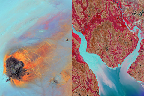
Top Stories
Students Sink Teeth into New Science Museum Exhibit
A new exhibit opening 1 May 2026 at the University of Louisiana at Lafayette Science Museum is putting student creat
A $364,874 National Science Foundation (NSF) grant to the UL Lafayette Regional Application Center (RAC) will enhance satellite imagery research and benefit students in our earth and energy sciences PhD program.
According to RAC director Brent Yantis, who is the principal investigator on the NSF grant, “The RAC provides the capability to directly and indirectly receive, enhance and disseminate satellite and other remotely sensed and geospatial data effectively and inexpensively in near real time for earth resource application development.”
It’s a significant capability, since the imagery and data assist with land management, coastal restoration, urban growth and planning, forest monitoring, natural resource management, disaster response, water quality and agricultural irrigation considerations.
The Regional Application Center collaborates with a range of governmental agencies and entities that rely on such information. They include NASA, the U.S. Geological Survey, and the National Oceanic and Atmospheric Administration. RAC data is also available to the public.
The center will continue to help address workforce needs. The NSF grant is designed to foster interest in earth and energy sciences and geographic information systems technology. That’s important because GIS “is expanding into many aspects of many careers and disciplines,” Yantis said. The technology enables researchers to create, manage and map data from a range of sources.
The grant will pave the way for outreach, including the creation of a bridge program for high school students. University faculty members and students will lead service-learning projects at area school districts. Courtney Poirier, a first-year earth and energy sciences doctoral student and graduate teaching assistant, will be among them. Her guidance will be based on experience she gleaned during an advanced GIS applications course taught by Yantis.
“Using what I learned from that class, I hope to mentor and help students develop their own research questions and to create a GIS-based project that they will then design and illustrate as a story map,” she said.
The bridge program is intended to spur interest in science, technology, engineering and mathematics, or STEM, careers. “Working alongside the sciences and geography disciplines – we refer to it as not only STEM education, but STEAM – because we’re adding art into the mix,” Yantis said.
That includes with the RAC’s ongoing participation in the “Earth as Art” program. The USGS program was launched in 2002 to educate the public about satellite imagery that informs scientific research. UL Lafayette students who take part enhance images of the Earth’s surface captured by NASA and USGS. The Regional Application Center displays the pieces at schools, museums, civic buildings and other events and places.
To create the pieces, students trace river paths, accentuate mountains or large swaths of ice-covered terrain, and splash oceans with vivid colors and hues. Their renderings blend art and science. It’s an intersection that provides insight into Earth’s geographical or ecological processes and produces exhibit-worthy abstract art.
“We teach students how to display the data in a way that’s relatable to the public viewing the images and piques their imagination, but without altering scale and other components of the remotely sensed images,” Yantis explained.
Photo caption: The National Science Foundation has awarded UL Lafayette’s Regional Application Center a $364,874 grant to help advance its research and outreach efforts centered around satellite images captured from space and other remotely sensed and geospatial capabilities. (Photo credit: Rachel Rafati / University of Louisiana at Lafayette)